Research
Earth Crust and Lithosphere
Research devoted to the structure and properties of the Earth Crust and Lithosphere is based on forward density modeling and integrated modeling of gravity anomalies, geoidal undulations, topographic heights and surface heat flow, on 2D transects or in 3D, making use of all possible geophysical and gelogical constraints such as interpretations of reflection and refraction seismics, geothermics, geomorphology, existing tectonic and geological interpretations. We focus on the Carpatho-Pannonian region.
Inversion Methodology
Research devoted to development of and innovations in methods for solving the gravimetric inverse problem. A so called „Harmonic Inversion Method" has been developed at our department. We were involved in developing the so called „Truncation Filtering Methodology" based on a sequence of systematically varying the truncation parameter in the Stokes convolution integral for the computation of the geoid from gravity anomalies. We participate in enhancing the applicability of a novice and very verstaile inversion methodology, consisting of several steps: removal of a regional trend defined as a 2D harmonic function, vertical separation of signal of sources by triple harmonic continuation procedure, approximation of multiple sources by line segments, non-linear inversion based on local corrections producing contrast contact structural surfaces (interfaces) and/or homogenous 3D star-convex anomalous sources.
Geothermics
Research primarily devoted to modelling of the temperature field of the Western Carpathian's lithosphere and surrounding tectonic units. Development of suitable modeling approaches and numerical procedures for the interpretation of geothermal data in complex geological structures influenced by relatively young tectonic events i.e. solution of both direct and inverse geothermal problems in steady state or transient regime. Prospection of deep geothermal energy sources in Slovakia by means of geothermic methods.
Geodynamics
Research devoted to the study of earth tides and crustal deformations, monitoring and interpretation of extensometric measurements. Special attention is paid to the aperiodic component of the extensometric data with implications to slow tectonic crustal deformations, and to the derivation of rheological properties of the earth crust. We deal also with interpretation of surface deformations and gravity changes observed in active or awakening volcanic areas.
Microgravimetry
Research devoted to interpretation of detailed microgravity surveys with applications in archaeological investigations or geohazards, aiming at detection of shallow cavities such as crypts, hidden rooms and bunkers at historical or cultural sites, or abandoned mine-workings at urban sites. Microgravimetry is combined with georadar wherever possible. Detailed topographic correction, so called building correction, for the effect of building walls and other architectural features is calculated using an in-house program Polygrav that utilizes 3D
The main subject of the work is a numerical modelling of the deformation characteristics of the rock structures by means of finite element method (FEM) applied in the field of gravimetry and geodynamics. The particular application is the modelling of the influence of the cavity effect on the tidal tilt measurements.
Calculation of temperature distribution and rheological properties of the lithosphere along transect I in the Western Carpathians
Written by Jana Dérerová | Published in: Earth Crust and Lithosphere |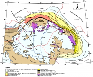
Jana DÉREROVÁ1, Igor KOHÚT1, Miroslav BIELIK1,2, Marián BOŠANSKÝ2, Barbora PORUBČANOVÁ1
1 Geophysical Institute of the Slovak Academy of Sciences
2 Department of Applied and Environmental Geophysics, Faculty of Natural Sciences, Comenius University
Introduction
The Carpathian-Pannonian Basin region, due to its complexity, represents a challenging area to study the influence of different parameters on the lithospheric rheology. In a relatively small area, many different thermotectonic units occur. The Pannonian Basin is young and hot, whereas the Western Carpathians being also young are colder. The thermotectonically old lithosphere represented by the Bohemian Massif and the European platform, which underthrust beneath the Western Carpathians, forms a sharp rheological contrast to the former two lithospheric units. Furthermore, the abundance of geophysical data such as deep seismic reflection and refractions profiles, gravity, radiometric and surface heat flow data provide valuable constraints on tectonic models of the area. For that reason, we applied 2-dimensional integrated modeling algorithm to calculate rheological model of the lithosphere along transect I passing through the Carpathian-Pannonian basin region.
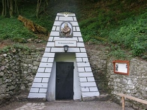
GPS coordinates:
48° 29′ 52″ N, 18° 49′ 44″ E
Our department operates a tidal station in Vyhne. The tidal station is located underground, in the gallery of St. Anthony of Padua in the Vyhne valley, Štiavnické vrchy Mts., Central Slovakia. Currently, it is equipped with quartz tube extensometer measuring the long-periodic (Earth's tides, annual temperature variations etc.) and aperiodic (tectonic) deformations of the Earth's crust. Since the end of 2005 the station is equipped with an α–particle counter to monitor the Radon emanation. In the beginning of 2006, a radio-frequency telemetric link connecting the seismological and tidal stations was established. With the satellite data connection of the seismic station Vyhne with the headquarters of the Geophysical Institute provided earlier, the data route from the tidal station's datalogger to our Bratislava workplace is now complete. Thus, the data acquisition process can be controlled better and the dropouts of data are prevented or minimized.
Interpretation of gravity changes at Mayon stratovolcano, Philippines
Written by Peter Vajda | Published in: Geodynamics |
Peter Vajda1, Ilya Prutkin2, Robert Tenzer3 and Gerhardt Jentzsch2
1 Geophysical Institute, Slov. Academy of Sci., Bratislava, Slovakia,
This email address is being protected from spambots. You need JavaScript enabled to view it.
2 Institute of Geosciences, Jena University, Jena, Germany
3 National School of Surveying, University of Otago, Dunedin, New Zealand
Gravimetric picture of the 2004 volcanic unrest on Teide, Tenerife, Canary islands
Written by Peter Vajda | Published in: Geodynamics |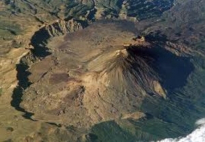
Gravity changes observed around Teide (Tenerife) between May 2004 and July 2005, due to the suspected reawakening of the volcano, were reinterpreted by us. Our objective was to seek multiple sources of the observed gravity signal. Our interpretation is based on the decomposition of the gravity signal into shallow and deep fields, and subsequent inversion of each field by means of 3D line segments. The shallow (near-surface) segments are interpreted as hydrothermal fluids. A short deep segment was found at the depth of about 6 km below sea level, interpreted as magma injection. Our results indicate that the 2004 volcanic unrest at the Central Volcanic Complex of Tenerife was a failed eruption.