Research
Earth Crust and Lithosphere
Research devoted to the structure and properties of the Earth Crust and Lithosphere is based on forward density modeling and integrated modeling of gravity anomalies, geoidal undulations, topographic heights and surface heat flow, on 2D transects or in 3D, making use of all possible geophysical and gelogical constraints such as interpretations of reflection and refraction seismics, geothermics, geomorphology, existing tectonic and geological interpretations. We focus on the Carpatho-Pannonian region.
Inversion Methodology
Research devoted to development of and innovations in methods for solving the gravimetric inverse problem. A so called „Harmonic Inversion Method" has been developed at our department. We were involved in developing the so called „Truncation Filtering Methodology" based on a sequence of systematically varying the truncation parameter in the Stokes convolution integral for the computation of the geoid from gravity anomalies. We participate in enhancing the applicability of a novice and very verstaile inversion methodology, consisting of several steps: removal of a regional trend defined as a 2D harmonic function, vertical separation of signal of sources by triple harmonic continuation procedure, approximation of multiple sources by line segments, non-linear inversion based on local corrections producing contrast contact structural surfaces (interfaces) and/or homogenous 3D star-convex anomalous sources.
Geothermics
Research primarily devoted to modelling of the temperature field of the Western Carpathian's lithosphere and surrounding tectonic units. Development of suitable modeling approaches and numerical procedures for the interpretation of geothermal data in complex geological structures influenced by relatively young tectonic events i.e. solution of both direct and inverse geothermal problems in steady state or transient regime. Prospection of deep geothermal energy sources in Slovakia by means of geothermic methods.
Geodynamics
Research devoted to the study of earth tides and crustal deformations, monitoring and interpretation of extensometric measurements. Special attention is paid to the aperiodic component of the extensometric data with implications to slow tectonic crustal deformations, and to the derivation of rheological properties of the earth crust. We deal also with interpretation of surface deformations and gravity changes observed in active or awakening volcanic areas.
Microgravimetry
Research devoted to interpretation of detailed microgravity surveys with applications in archaeological investigations or geohazards, aiming at detection of shallow cavities such as crypts, hidden rooms and bunkers at historical or cultural sites, or abandoned mine-workings at urban sites. Microgravimetry is combined with georadar wherever possible. Detailed topographic correction, so called building correction, for the effect of building walls and other architectural features is calculated using an in-house program Polygrav that utilizes 3D
Temporal gravity changes and surface deformations interpretation
Written by Peter Vajda | Published in: Geodynamics |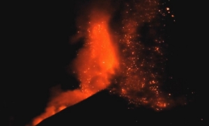
Measurable temporal changes of gravity and deformations of earth's surface are indicators of dynamic processes inside the earth, such as those associated with movements of magma preceding volcanic eruptions. The observation, analysis and interpretation of surface gravity changes and vertical displacements of the topographic surface contribute to understanding the physics of magma reservoirs and the processes associated with volcanic activity.
Truncation Filtering Methodology
Written by Peter Vajda | Published in: Inversion Methodology |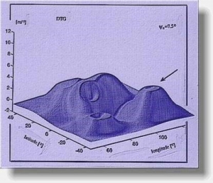
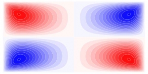
The Truncation Filtering Methodology (TFM) belongs to the gravity data interpretation methods based on data enhancement and pattern recognition. The TFM is still under development. It is based on filtering the gravity data by means of integral transforms - convolution integrals - with various kernels and one free parameter. This leads to not one image but to an animated sequence of images displaying dynamic patterns. The patterns and their onsets are expected to serve for determining various geological formations and features and for estimating the depth of some of their elements. Such a knowledge and method of interpretation are to be achieved by means of synthetic modeling and case studies.
The methods of the geothermal energy sources parameters determination and their application in the region of Slovakia.
The basic tasks of geothermal research
Written by Dušan Majcin | Published in: Geothermics | 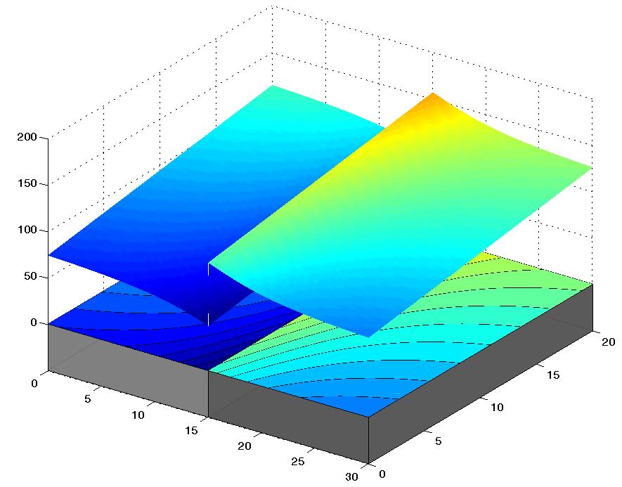
The solution of the problems of basic research of the temperature distribution and of the heat flow density components distribution caused by various types of the refractions and/or of the heat sources. The math-physical tasks in bounded 2D/3D areas are solved by means of finite difference, by finite element approaches, and by boundary elements methods. The temperature fields modeling results are utilized by interpretation of the data describing the thermal state of the lithosphere in the region of the Western Carpathians. The interpretation approaches are adapted both to concrete structural and tectonic conditions and to available geological and geophysical data.
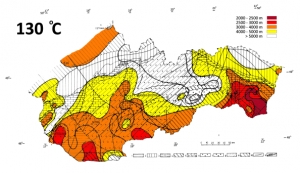
Modelling of the temperature field of the lithosphere of the Western Carpathians and of the surrounding tectonic units.
Written by Dušan Majcin | Published in: Geothermics ||
Correlation map of the terrestrial heat flow density distribution (colour scale in mW/m²) and lithosphere thickness distribution (in km) both from geothermal data (military green solid and dashed isolines) and from magnetotelluric data at the determination positions (blue colour stars and values). |
|

References
Majcin, Dušan. Computation of the temperature distribution along the DSS profiles running through Slovakia (1988) Contributions - Slovak Academy of Sciences, Geophysical Institute, 18, pp. 37-58.
Bielik, Miroslav - Majcin, Dušan - Fusán, Oto - Burda, Miroslav - Vyskočil, Vincenc - Trešl, Jiří. Density and geothermal modelling of the Western Carpathian Earth's crust (1991) Geologica Carpathica, 42, 6, pp. 315-322
Majcin, Dušan.Thermal state of the west carpathian lithosphere (1993) Studia Geophysica & Geodætica, 37 (4), pp. 345-364
Majcin, Dušan - Tsvyashchenko, Vladimír Alexandrovič . Effect of magmatism on temperature field in the northern part of the Transcarpathian depression. (1994) Contrib. Geophys. Geod., 24, pp. 72 - 86
Majcin, Dušan - Dudášová, Viera - Tsvyashchenko, Vladimír Alexandrovič . Tectonics and temperature field along the Carpathian profile 2T. (1998) Contrib. Geophys. Geod., 28, pp. 107 - 114
Lankreijer, Anco - Bielik, Miroslav - Cloetingh, Sierd - Majcin, Dušan. Rheology predictions across the western Carpathians, Bohemian massif, and the Pannonian basin: Implications for tectonic scenarios. In Tectonics. - American Geophysical Union : Washington. ISSN 0278-7407, (2000), vol. 18, no. 6, p. 1139-1153. (2.800 - IF1999). 2/5136/98
Majcin D., Bilčík D., Kutas R.I., Hlavňová P., Bezák V., Kucharič Ľ., 2014: Regional and local phenomena influencing the thermal state in the Flysch belt of the northeastern part of Slovakia. Contrib. Geophys. Geod., 44/4, 271-292.
Kutas R.I., Majcin D., 2014: Geothermal conditions for Neovolcanism in Transcarpathian through. Geology, 66/3, Kiev, 39-43 (in Russian).
Majcin D., Bilčík D., Klučiar T., 2015: Thermal state of the lithosphere in the Danube Basin and its relation to tectonics. Contributions to Geophysics and Geodesy Vol. 45/3, 193–218
Development and implementation of analytical (method of crosswise superposition, of homogeneous solutions) and discrete methods of solving linear elasticity rock mechanics problems with gravity loading. Presently, the main objective is their application to the investigation of the behaviour of speleothems (cave sinter formations) under gravitational and inertial loading, with the aim to make conclusions about paleoseismicity and paleotectonics.