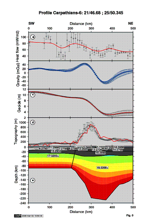
2D integrated modelling method that combines joint interpretation of surface heat flow data, topography, gravity anomalies (Bouguer or free air) and geoid, serves for determination of lithospheric thickness and structure. A two-dimensional finite element (FE) algorithm is used to calculate the steady state temperature distribution in the lithosphere, with the following boundary conditions:
- constant surface temperature,
- no lateral heat flow at the vertical model boundaries,
- constant temperature at the base of the lithosphere.
The base of the lithosphere is modified interactively in order to find the best fitting model. The model space is subdivided into bodies corresponding to sediments, upper, middle, and lower continental crust, oceanic crust and lithospheric mantle. These bodies are characterized by their density, thermal conductivity and heat production. Once the temperature distribution has been determined, the densities are evaluated at each node of the FE grid and with this density distribution, the gravity, geoid, and topography anomalies are calculated. Topography is calculated under the assumption of local isostatic equilibrium with the compensation depth at the deepest point of the lithosphere within the model space. The obtained topography variations are calibrated with respect to average mid-oceanic ridge bathymetry. The gravity anomalies are calculated in two dimensions using the algorithm of Talwani. For the calculation of the geoid, the triangular elements of the grid is converted into rectangular prisms with a large lateral extension in order to simulate two-dimensional anomalies and calculate the anomaly.

Lithospheric model along Profile 6 (with exact
coordinates)
(a) - surface heat flow, (b) free-air gravity anomaly,
(c) - geoid,
(d) - topography with dots corresponding to measured data with
uncertainty bars and solid lines to calculated values,
(e) - lithospheric
structures.