
Modelling of the temperature field of the lithosphere of the Western Carpathians and of the surrounding tectonic units.
Approaches of the construction of the primer material models and of the models of tectonic elements; methodology of the solution of the inverse problems; analytical and numerical solutions of mathematic-physical problems of the stationary and of the transient heat transfer within the inhomogeneous 1D - 3D medium; construction of the software packages; the application of the geothermal modelling methods for investigation of the lithosphere thermal state in the regions under study; the construction of the graphic outputs in the form of the vertical and horizontal cuts and also of the maps of the temperature distribution and of the distribution of heat flow density components on various geological boundaries.
References
Majcin, Dušan. Computation of the temperature distribution along the DSS profiles running through Slovakia (1988) Contributions - Slovak Academy of Sciences, Geophysical Institute, 18, pp. 37-58.
Bielik, Miroslav - Majcin, Dušan - Fusán, Oto - Burda, Miroslav - Vyskočil, Vincenc - Trešl, Jiří. Density and geothermal modelling of the Western Carpathian Earth's crust (1991) Geologica Carpathica, 42, 6, pp. 315-322
Majcin, Dušan.Thermal state of the west carpathian lithosphere (1993) Studia Geophysica & Geodætica, 37 (4), pp. 345-364
Majcin, Dušan - Tsvyashchenko, Vladimír Alexandrovič . Effect of magmatism on temperature field in the northern part of the Transcarpathian depression. (1994) Contrib. Geophys. Geod., 24, pp. 72 - 86
Majcin, Dušan - Dudášová, Viera - Tsvyashchenko, Vladimír Alexandrovič . Tectonics and temperature field along the Carpathian profile 2T. (1998) Contrib. Geophys. Geod., 28, pp. 107 - 114
Lankreijer, Anco - Bielik, Miroslav - Cloetingh, Sierd - Majcin, Dušan. Rheology predictions across the western Carpathians, Bohemian massif, and the Pannonian basin: Implications for tectonic scenarios. In Tectonics. - American Geophysical Union : Washington. ISSN 0278-7407, (2000), vol. 18, no. 6, p. 1139-1153. (2.800 - IF1999). 2/5136/98
The basic problems of the geothermal research.
The solution of the problems of basic research of the temperature distribution and of the heat flow density components distribution caused by various types of the refractions and/or of the heat sources.
References
Majcin, Dušan. Refraction of heat flow on the near-surface structures with thermal conductivity contrast (1993) Contributions - Slovak Academy of Sciences, Geophysical Institute 22, pp. 67-80
Majcin, Dušan - Polák, Szilárd. Refraction of heat flow near the border of the sedimentary basins with topography. (1995) Contrib. Geophys. Geod., 25, pp. 99 - 112
Hvoždara, Milan - Majcin, Dušan. Geothermal refraction problem for 2-D body of polygonal cross-section buried in the two-layered earth (2009) Contributions to Geophysics and Geodesy, vol. 39/4, 301-323.
Geothermal energy.
The methods of the geothermal energy sources parameters determination and their application in the region of Slovakia.
References
Franko, Ondrej - Fusán, Oto - Král, Miroslav - Majcin, Dušan. Rozloženie vysokoteplotných a strednoteplotných geotermálnych vôd a tepla suchých hornín na Slovensku. (1986) Geotermálna energia Slovenska a jej využitie . Geologický ústav D. Štúra, pp. 81-92
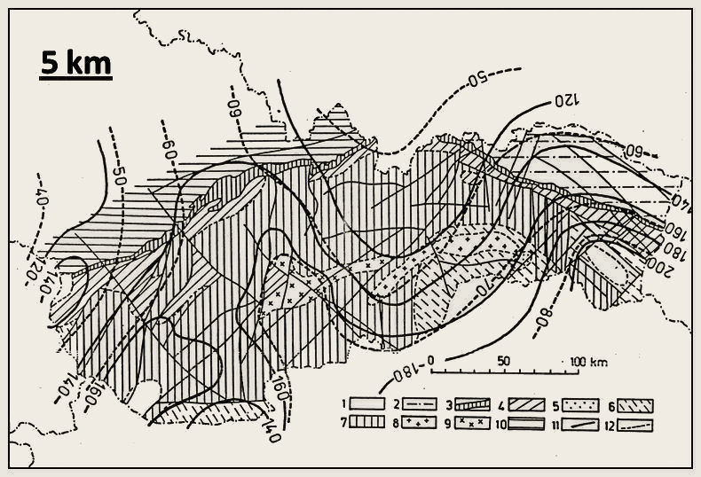
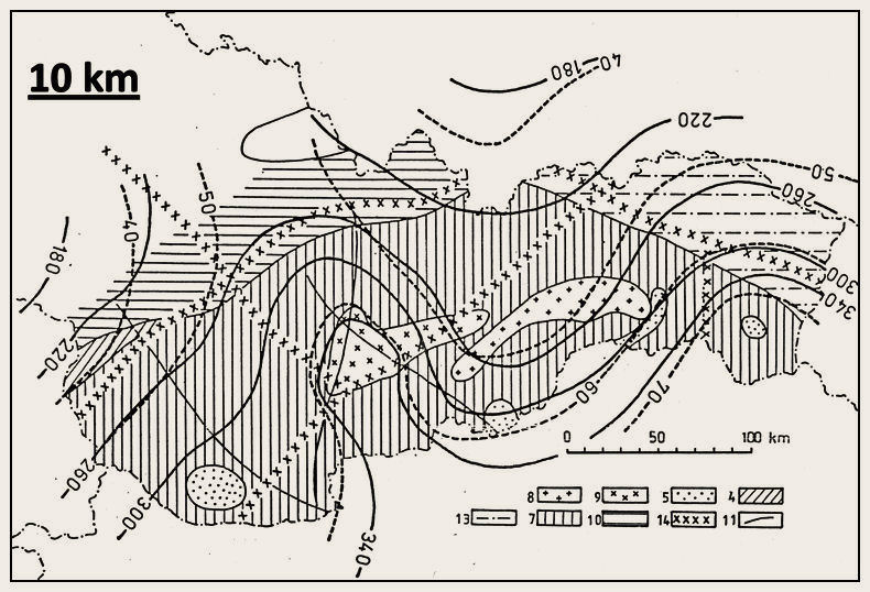
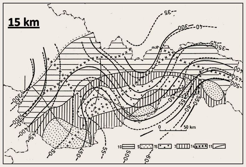
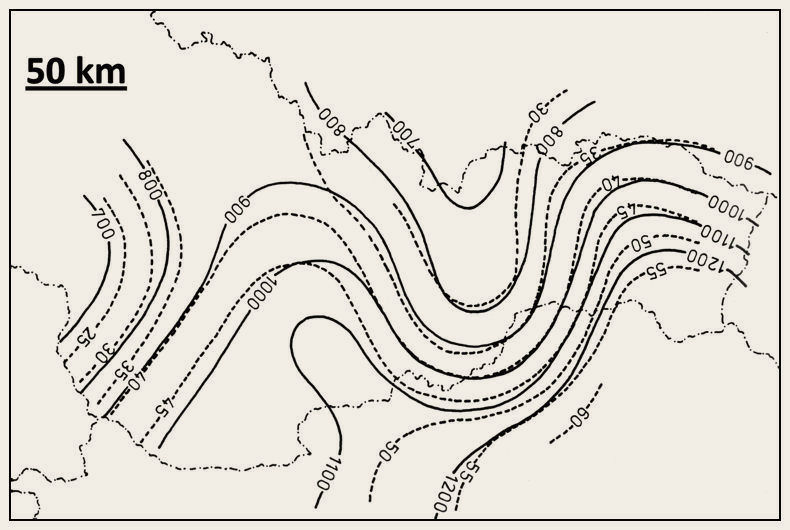
Fig. 1a, 1b, 1c, 1d. Regional character of the temperature field ( thick solid lines with values in °C) and of the vertical component of the heat flow density ( thick dashed lines with values in mW/m2) at the depths of 5, 10, 15 and 50 km. Geological structures: 1- Neogene sediments, 2 - Paleogene flysh, 3 - Klippen Belt, 4 - Inner Carpathian Mesozoic, 5 - basic bodies, 6 - Paleozoic sediments and vulcanites, 7 - crystalline schists and granitoids, 8 - Cretaceous intrusive granitoids, 9 - Neogene intrusive diorites and gabrodiorites, 10 - platform units, 11 - faults, 12 - assumed boundaries, 13 - outher Carpathian flysch, 14 - deep seated faults, 15 - alpine granitoids
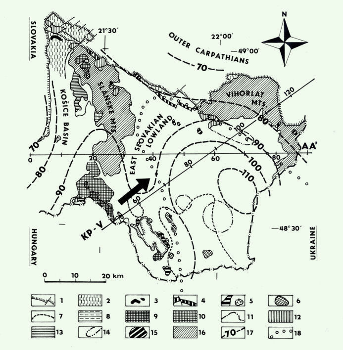
Fig. 2a. Neogene volcanism and the direction of its time migration in the East-Slovakian Basin and position of profiles KP-V and AA’. 1 - pre-Neogene basement, 2 - sediments of the Lower Miocene age, 3 - rhyolite pyroclastic rocks in sediments (Lower Badenian), 4 - rhyolite-pyroclastic rocks in marine sediments (Lower Badenian), 5 - rhyolites and rhyolite pyroclastic rocks (Upper Badenian), 6 - andesites (Upper Badenian) at the surface, 7 - buried andesite complexes (Upper Badenian), 8 - rhyolite tufs (Lower - Middle Sarmatian), 9 - rhyolites (Lower Sarmatian), 10 - andesite stratovulcanoes (Lower Sarmatian), 11 - buried stratovolcanoes (Lower Sarmatian), 12 - intrusions and domes of diorite porphyry (Middle - Upper Sarmatian), 13 - extrusive bodies and breccias of pyroxene-hornblende andesites ( Middle - Upper Sarmatian ), 14 - buried volcanoclastic complexes of pyroxene-hornblende andesites ( Middle - Upper Sarmatian ), 15 - domes and cumulodomes of garnet-bearing plagioclase rhyolites (Lower Sarmatian - Pannonian?), 16 - stratovolcanoes and lava fields formed by andesites, dacite, basaltic andesites (Upper Pannonian - Romanian), 17 - the surface heat flow density isolines; 18 - boundary of the regional gravity anomaly
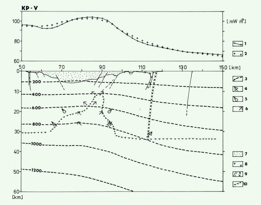
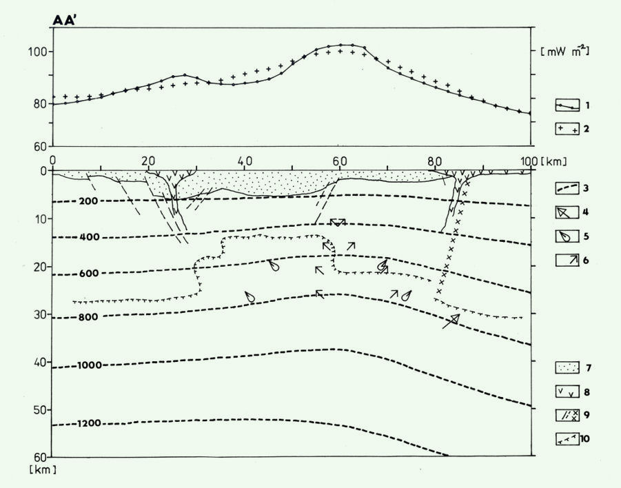
Fig. 2b, Fig. 2c. Model of temperature field on profile KP-V and AA’. 1 - observed surface heat flow density, 2 - calculated heat flow density, 3 - temperature field isolines in Celsius grade, 4 - boundary of source approximating activation of the geosyncline, 5 - maximal lateral boundaries of the diapir in the lower crust (Middle Badenian), 6 - boundaries of the magmatic body connected with youngest activation (5-6 Ma), 7 - sedimentary filling of the Neogene basin, 8 - neovolcanites, 9 - fractures and deep faults, 10 - presumed upper mantle and diapir boundary from seismic and gravity data
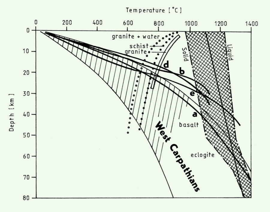
Fig. 2d. Vertical temperature distribution in the central part of the East-Slovakian Basin. e - Eggenburgian, b - Middle Badenian, d - Dacian, a - recent distribution
